
Fitxategi:Europe 1812 map de.png

Aurreikuspen honen neurria: 800 × 526 pixel. Bestelako bereizmenak: 320 × 211 pixel | 640 × 421 pixel | 1.024 × 674 pixel | 1.280 × 842 pixel | 2.284 × 1.503 pixel.
Bereizmen handikoa ((2.284 × 1.503 pixel, fitxategiaren tamaina: 1,13 MB, MIME mota: image/png))
Fitxategi hau Wikimedia Commonsekoa da. Hango deskribapen orriko informazioa behean duzu. |
Laburpena
| Deskribapena |
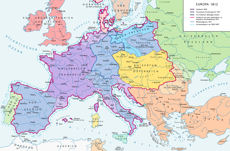
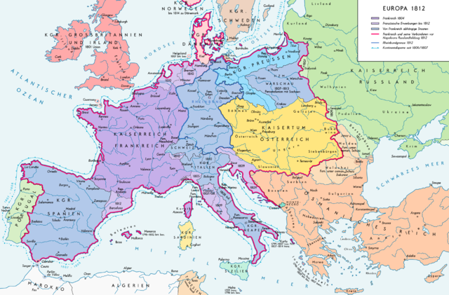
Deutsch: Europa 1812. Politische Ausgangslage vor Napeoleons Russlandfelzug. English: Europe in 1812. Political situation before Napoleon's Russian Campaign. |
| Data | |
| Jatorria |
Norberak egina. Source of Information: – Map «L’apogée de l’Empire Français (avant la campagne de Russie)» (Author unknown) Fehlerhafter Link: (Link) – Dr. Walter Leiserung (ed.): Historischer Weltatlas, Marix Verlag, Wiesbaden 2004, ISBN 978-3-937715-59-9 – Zentralinstitut für Geschichte der Akademie der Wissenschaften der DDR (ed.): Atlas zur Geschichte, Band 1, VEB Hermann Haack, Gotha 1989, ISBN 3-7301-0040-8 – Prof. Dr. Vadim Oswalt, Prof. Dr. Hans Ulrich Rudolf (ed.): Klett-Perthes Atlas zur Weltgeschichte, Ernst Klett Verlag, Stuttgart 2011, ISBN 978-3-12-828194-0 – Ferenc Majoros u. Bernd Rill: Das Osmanische Reich 1300-1922. Die Geschichte einer Großmacht, Lzenzausgabe für Weltbild Verlag, Augsburg 2000, ISBN 3-8289-0336-3 |
| Egilea | Alexander Altenhof |
| Beste bertsioak |
|

Lizentzia
Nik, lan honen egileak, argitaratzen dut ondorengo lizentzia pean:
Fitxategi hau Creative Commons Attribution-Share Alike 3.0 Unported lizentziapean dago.
- Askea zara:
- partekatzeko – lana kopiatzeko, banatzeko eta bidaltzeko
- birnahasteko – lana moldatzeko
- Ondorengo baldintzen pean:
- eskuduntza – Egiletza behar bezala aitortu behar duzu, lizentzia ikusteko esteka gehitu, eta ea aldaketak egin diren aipatu. Era egokian egin behar duzu hori guztia, baina inola ere ez egileak zure lana edo zure erabilera babesten duela irudikatuz.
- berdin partekatu – Lan honetan oinarrituta edo aldatuta berria eraikitzen baduzu, emaitza lana hau bezalako lizentzia batekin argitaratu behar duzu.
Fitxategiaren historia
Data/orduan klik egin fitxategiak orduan zuen itxura ikusteko.
| Data/Ordua | Iruditxoa | Neurriak | Erabiltzailea | Iruzkina | |
|---|---|---|---|---|---|
| oraingoa | 17:25, 11 iraila 2016 | | 2.284 × 1.503 (1,13 MB) | KaterBegemot | Border corrections at Thorn and Tarnopol area, minor kerning and positioning changes, smaller font at Swedish Pomerania |
| 02:48, 20 uztaila 2016 |  | 2.284 × 1.503 (1,14 MB) | KaterBegemot | Added Bukovina / Marked Corfu as territory under French influence (red) / Correct position of city points of Basel, Geneva, Toulouse / Minor border corrections / Better kerning / Thinner map legend border | |
| 02:23, 14 uztaila 2016 |  | 2.284 × 1.503 (1,13 MB) | KaterBegemot | Added P. of Neuchatel, Ekaterinoslav, Varna, Brăila / Corrected borders of Montenegro, Milan-Genoa area / Deleted border of map | |
| 23:33, 5 urria 2013 |  | 2.293 × 1.512 (1 MB) | KaterBegemot | Corrected boundaries of Switzerland, Prussia and Circassia | |
| 19:56, 16 iraila 2012 |  | 2.293 × 1.512 (1 MB) | KaterBegemot | Minor fixes | |
| 17:50, 10 iraila 2012 |  | 2.293 × 1.512 (1 MB) | KaterBegemot | Corrections | |
| 18:31, 8 iraila 2012 |  | 2.293 × 1.512 (1.019 KB) | KaterBegemot | == {{int:filedesc}} == {{Information |Description= {{de|1=Europa 1812. Politische Ausgangslage vor Napeoleons Russlandfelzug.}}{{en|1=Europe in 1812. Political situation before Napoleon's Russian Campaign.}} |Source={{Own}}. Source of Information: </br... |
Irudira dakarten loturak
Hurrengo orrialdeek dute fitxategi honetarako lotura:
Fitxategiaren erabilera orokorra
Hurrengo beste wikiek fitxategi hau darabilte:
- de.wikipedia.org proiektuan duen erabilera
- en.wikipedia.org proiektuan duen erabilera
- zh.wikipedia.org proiektuan duen erabilera